I guess the right thing to do for the last journal entry is to ask myself, what I have I learned about cities, planning and public spaces? Two main lessons I have learned might be:
One thing I have learned, primarily from the readings of Chicago, is the way that cities are connected to the countryside or "hinterland". I knew that cities relied on the surrounding countryside for resources, but reading about the way Chicago grew as a result of its large hinterland made me realise just how connected they are, and how defining areas as either the "country" or the "city" is potentially misleading as it poses them as two separate entities.
Another thing I learned about was how to look at cities. Looking at (but not only) the urban form, the people, the planning policies, the economic flows etc. Previously, and in line with my Architecture degree, I would have looked only at the urban form, but I know in greater depth now how much other elements affect the final urban form and the people. Particularly the idea of "flows" discussed in the most recent lecturers was interesting, as it identifies and emphasises how things are changeable through time and space. Previously when discussing things changing through time I would have said that something might be "transient", but it implies that this characteristic, whether it is the sunlight, weather, people, economic regimes etc comes and then disappears. The use of the idea of flows however implies that things morph, change, collide, interact, and feed of each other.
Of course there are more, but I feel that as I continue my architecture degree, travel, and see more of the world, what I see and experience will continue remind me of lessons learned in this course.
Friday, May 24, 2013
Feeling
One of the things that stuck with me from the walking tour the other day in Alexandria, was when we were standing on the residential road behind the cafe and talking about the two sides of the street in relation to the way the cars were parked. Unless I am remembering incorrectly, Michael asked us how we "felt" about the space, and that how we feel about a space is generally a good indicator of its characteristics and design. I thought this was interesting, as it isn't something I have consciously asked myself regularly at all, although it is something that definitely informs how I use spaces and where I choose to position myself within a space or street. When analysing a space, I have rarely asked myself how I "feel" as I thought feeling is a more subjective, emotional method of looking at a space, rather than looking at the architectural details, or the way the light enters a room, or the use of materiality. But it makes sense - if you ask yourself "how do I feel in this space" and you decide you feel a certain way, whether you feel good, comfortable, claustrophobic, uneasy, subdued, excited etc., you can then ask yourself "why" you feel that way. Do I feel uncomfortable because of the low ceiling height? Do I feel subdued because of materiality allows for long reverberations which means any sound I make is amplified? Do I feel excited because when I enter the space (e.g. a night club), I can immediately see everyone below me interacting and dancing and having fun, and that I can't wait to go down the stairs to join them?
For example right now sitting close to the base of the stairs of Surry Hills Library on the basement level, I can say that I feel tired but comfortable and slightly distracted. My tiredness has to do with staying up late to finish assignments, but the other two are more to do with where I am located in the library. I feel comfortable, because I am sitting at my own small table next to a wall, and the way that I am facing means I can see the people (i.e. attractive boy) sitting in front of me, and also watch people coming and going down the stairs. It is interesting to note that 5 of the 6 people sitting at the 6 tables along this same line of desks are all orientated so they are facing the stairs.
I also have oblique, partial views towards the bookshelves, and large glazed facade to the stormy sky, which all give me a sense of my location. However my views are partially blocked by the wall I am sitting next to, the column and massing of the stairs in front of me, and a bookshelf to my left, which also make me feel enclosed and comfortable, almost like I am nested within a space. The colour scheme around me is black and white, with light shining on a beautiful timber double height ceiling. This means that I am not distracted visually by bright colours, but if I look up, the light reflected on the timber makes me feel warm and cosy, like I am in my lounge room.
Finally I feel a bit distracted every so often from writing this post, because of the sounds of children playing on the level above travelling down the void above me. While for me the use of white noise or background noise is helpful to working, and the sounds of children playing is quite homely and comfortable, the sound of children fighting or crying are not. I feel it would be better if the children's play area were more acoustically separated from the study area, without blocking the visual access.
Thursday, May 23, 2013
The Movable Chair
Referring to William H Whyte's video The Power of the Movable Chair, I was thinking, where in Sydney, in a public space not attached to a cafe, or restaurant has movable chairs? I can't think of anywhere I have been recently that has something similar to the spaces discussed by Whyte.


One example I can think of that has an interesting variety of seating within a highly urban space is the World Square plaza on George street.
(From http://cdn1.agoda.net/hotelimages/108/108524/108524_080913000100182027_STD.jpg)
These seats face onto George Street, and provide various heights from which people can watch the street.
(from http://www.bonhomiephotos.com/wp-content/uploads/2013/04/20130411-RE7A4635-1140x395.jpg)
Temporary and permanent chairs in the central square. These are ideal as they allow for various seating arrangements, and the ability for people to orientate themselves how they wish to face the sun, face a friend, or watch people passing by.
(from http://www.conferenceaustralia.com/hotel_images/rydges-world-square--2018134e.jpg)
In the far back left, seating can be seen placed close to the planting so that people are given the choice of whether to sit out in a large open space, or next to a structural element or planting.
(from http://whatson.cityofsydney.nsw.gov.au/system/event_images/69804/large_xmas.JPG?1321941815)
Outdoor cafe seating with sheltering elements can be seen in the far left.
(from https://blogger.googleusercontent.com/img/b/R29vZ2xl/AVvXsEiMMikfzsVKQBGvKo9pGhc_BTP_wilIj7v0qhcanJ48JVtFMLoRIk3MYGi557Br7cmSRBLz4QetEACCeHF5BlmtZbOSMlDhH2eqP4ikXk_kLL2Gw4SgOajiP4w15fUz9yY12PpPws7aBAct/s1600/taste2.JPG)
A variety of cafe seating in the sheltered urban corridors between structural elements. These columns help define and give rhythm to the space.
Monday, May 20, 2013
Spontaneity in Surry Hills
So a little while ago, a friend and I were enjoying a beverage on the balcony of the Clock Hotel overlooking Crown Street when this happened:
Surry Hills Marching Band
One of the things I enjoy most about Crown Street is the way the suburb invites spontaneous actions and events, such as a moving marching band, or in another case a Ben and Jerry's icecream van with chalk drawing on the pavement, or even just kids playing football with their mums in the park. What makes it great is that the events, especially in the little square next to the Surry Hills Library, are so visible given the amount of restaurants in the area, and the foot traffic and car traffic passing by. And also the fact that the event in contained in a area usually bordered by low rise terrace houses that are built right up to the street, which encloses the event in what is almost like a room. Other areas off the top of my head that might be similar might be King Street in Newtown, the promenade next to the sand down by Coogee Beach, or even the patch of grass, walkway and podium underneath and next to the Red Center.
All these areas have high amounts of foot traffic at certain times, and, with the exception of perhaps Coogee Beach, have an almost "room" or "corridor" like quality where the space is partially enclosed, increasing the relationships people in the space might have with each other. Kind of like being at a party in a house. Certainly I feel like I'm more likely to talk to people if we are collectively sharing in an event while being forced to be in close proximity to each other. Such events might potentially increase the intensity and methods by which members of a neighbourhood interact, contributing to a neighbourhood or suburb that "feels" friendly and where you "feel" like you might belong. I certainly feel very comfortable in places such as Surry Hills, Newtown and Coogee Beach, even more so than I do my own suburb of Maroubra. This is possibly due to the high amount of people my age living in these suburbs, as well as the amount of interesting cafes, bars, galleries, and shops that I could potentially go to that suit my lifestyle. This is potentially why I choose to work in a restaurant in Surry Hills that takes me 45 minutes to get to by bus, instead of a more local job (such as my old job in a bottleshop) that I can walk to in 5 minutes. Even at this very moment, I am on a break from work enjoying the Surry Hills Library. I guess the way I feel about Surry Hills is one of the many reasons why housing in these areas is in such demand - because people enjoy this type of urban lifestyle.
Ash
Sunday, May 19, 2013
Nutbush City Limits
On a lighter note, I just had a nostalgic moment and realised that the song we used to dance to back when I was 13 at school dances is partially to do with cities!
Which made me think, what other popular songs talk about cities?
Maybe Empire State of Mind - Jay Z and Alicia Keys about New York?
Or referencing Sydney -Reckless - James Reyne
And from when I was in Ireland last year - Rocky Road to Dublin - The Dubliners
Thursday, May 16, 2013
Road trip to Avoca
Last week, several friends and I drove up to Avoca for the day, where one of guys we were with grew up. Our return journey to Sydney was partly provided by my friends mother, who drove us from Avoca to Gosford Station. She obviously took a lot of pleasure in showing us around, and drove us down to a carpark on the waterfront, off the Central Coast Highway facing The Broadwater.
What reminded me of our Urban Design course was that while we were sitting in the car looking over the water, she told us a bit of the history of the area, and a few her opinions about the local development.

Surrounding the area are various pieces of infrastructure that contribute to the public nature of the space. One of the first things she mentioned was the presence of a cycle/walking path with which you can cycle around the entire bay. The location of the car park in relation to the bike path can be seen below.


a. Gosford Race Course
b. Gosford Train Station
c. Bluetongue Central Coast Stadium
d. Gosford TAFE Campus
e. (the carpark location)
f. Gosford Olympic Swimming Pool
Others include shopping centers, parks, schools, and shops.
Sitting in the car that afternoon, and that evening after I arrived home, I began to think of how all these elements contributed to the closing down of Iguanas, and could it have anything to do with the infrastructure or elements of the surrounding area. Given my limited knowledge of the area, the first two things I first observed that may have contributed could have been the presence of the Central Coast Highway, and the urban form of the blocks and buildings.

Above is a screenshot from Google Maps of the Central Coast highway, which separates the waterfront (and Iguanas visible to the left of the highway) from the residential and commercial parts of Gosford. While the plantings and trees surrounding the highway make it relatively pleasant to walk along, it still presents a major physical barrier to pedestrians trying to access the waterfront.

One of the most interesting things I noted while driving along the highway is the part seen above, where the highway is in extremely close proximity to both the Stadium and the waterfront.
As it appears, most major infrastructure or public spaces that would draw crowds of people, are separated from the waterfront (and Iguanas) by the highway. This means that the venue is most easily accessed by car, and not by walking.
The other observable element that may contribute is the amount of surface space taken up by parks and setbacks. While parts of the area are fairly heavily built up, with multilevel residential, shops, offices and houses joined by small streets and laneways, significant amounts of land are also filled in with parks and green open space, especially surrounding the location of the restaurant. Contributing to this is that many of the built up areas are located along the waterfronts of the various inlets and bays in the area, which would make the ideal form of transport a car due to the distances between potential destinations. The built up areas and location of the restaurant (in yellow) can be seen below.

Furthermore, my friends mother mentioned that the owner of the restaurant had been reassured by the local council that the waterfront would eventually be built up. This may have encouraged people to the area as well as further infrastructure, such as bus routes or bike lanes. However this never came to be and the restaurant was forced to close.
So from a fairly superficial analysis of the area based on observable characteristics of the suburb, as well as what my friends mother told us, I can suggest that it is potentially the low walkability of the area, due to the separating presence of the highway and amounts of open spaces that lead to the closure of the restaurant from a lack of patrons, despite promising amounts of public spaces and infrastructure available to diversity the area.
Thursday, May 9, 2013
Maroubra + Views
I was reading Kevin Lynch's The Image of the City (1960) for the project the other day, and was contemplating the sections on views. Views such as favourite views, or short views, or how views terminate etc.


Living in Ranelagh had many advantages. The location of my apartment was a 20 minute walk away from the main city center, or a 5 minute tram (LUAS) ride. The closest supermarket was a 5 min walk away, as were pharmacies, restaurants, bars, and retail shops. The housing was composed primarily of Georgian terraces divided up into apartments and were generally extremely well kept. The suburb has a high walkability, with high levels of infrastructure accessible to residents.
Living in Maroubra is extremely different with many contrasts. The closest big grocery store was a 15 min bus ride away or a 45 minute walk (to Maroubra Junction). The closest bars and restaurants would be at The Spot in Randwick, which was also a 15 minute busride or 45 minute walk away. Maroubra Beach has a very low amount of shops and restaurants available to residents, and most would go to The Spot, Randwick Junction, or Maroubra Junction for main shopping activities. Streets around Maroubra are generally pleasant with stand alone houses or apartments set back from the street. Areas of Maroubra, just like in Ranelagh, are composed of social housing/community housing and are less aesthetically attractive but generally still safe.
The main difference between the locations of my house that are apparent immediately, and that had the biggest effect on me when I arrived back home, are the views. The geography of Maroubra is such that it is is very hilly, and the location on the coast means that there are a variety of long to extremely long views. This sense of space and airiness is something that I sorely missed while living in Ranelagh. The parks and long walks along the cliffs at Maroubra enhances these views and provides easy access to areas for exercise and recreation. In Ranelagh, one would often see joggers running on the streets or along the canal that cuts through Dublin next to busy roads, however in Maroubra one has the option to run along the Coastal Walk that runs along the tops of the cliffs. I would say that I have a healthier, more outdoor lifestyle in Maroubra than I did in Ranelagh, and the variety of really beautiful views have a positive significant impact on my psychological wellbeing.
While I would argue that infrastructure is not as accessible without a car (I do not drive) in Maroubra as it is in Ranelagh, I would still say that I have a better standard of living in Maroubra due to the access to open areas and the beach, as well as the advantages of climate.
A little while later I was walking to my bus stop on a sunny morning in Maroubra Beach, thoroughly enjoying the sunshine and comparing it to where I lived in Dublin, Ireland last year. The areas were so different in many different ways, and it made me realise how much I appreciate living where I do now, even though I did enjoy my time in Dublin.

Above: The location of my apartment in Ranelagh, Dublin

Above: The location of my house in Maroubra, Sydney
Living in Ranelagh had many advantages. The location of my apartment was a 20 minute walk away from the main city center, or a 5 minute tram (LUAS) ride. The closest supermarket was a 5 min walk away, as were pharmacies, restaurants, bars, and retail shops. The housing was composed primarily of Georgian terraces divided up into apartments and were generally extremely well kept. The suburb has a high walkability, with high levels of infrastructure accessible to residents.
Living in Maroubra is extremely different with many contrasts. The closest big grocery store was a 15 min bus ride away or a 45 minute walk (to Maroubra Junction). The closest bars and restaurants would be at The Spot in Randwick, which was also a 15 minute busride or 45 minute walk away. Maroubra Beach has a very low amount of shops and restaurants available to residents, and most would go to The Spot, Randwick Junction, or Maroubra Junction for main shopping activities. Streets around Maroubra are generally pleasant with stand alone houses or apartments set back from the street. Areas of Maroubra, just like in Ranelagh, are composed of social housing/community housing and are less aesthetically attractive but generally still safe.
The main difference between the locations of my house that are apparent immediately, and that had the biggest effect on me when I arrived back home, are the views. The geography of Maroubra is such that it is is very hilly, and the location on the coast means that there are a variety of long to extremely long views. This sense of space and airiness is something that I sorely missed while living in Ranelagh. The parks and long walks along the cliffs at Maroubra enhances these views and provides easy access to areas for exercise and recreation. In Ranelagh, one would often see joggers running on the streets or along the canal that cuts through Dublin next to busy roads, however in Maroubra one has the option to run along the Coastal Walk that runs along the tops of the cliffs. I would say that I have a healthier, more outdoor lifestyle in Maroubra than I did in Ranelagh, and the variety of really beautiful views have a positive significant impact on my psychological wellbeing.
While I would argue that infrastructure is not as accessible without a car (I do not drive) in Maroubra as it is in Ranelagh, I would still say that I have a better standard of living in Maroubra due to the access to open areas and the beach, as well as the advantages of climate.
Sunday, April 28, 2013
Global Cities
In class yesterday while talking about Global Cities, I searched the term "global city" on my beloved pop culture Atlantic Cities website and came across two interesting articles. One was this one partly on the London riots and partly on the effects that class segregation can have on the urban fabric. This was one topic that was covered in class yesterday where Saskia Sassen in The Global City discussed the spatial outcomes of a global city wherein the juxtaposition of social classes is intensified. I think it is relevant to the riots and the article, especially where the author talks about the urban projects being pushed forward in his home of Toronto.
The other thing that struck me was this chart that ranks the world's global cities. I was mildly surprised to see Sydney ranked as number 12, somewhat higher than I initially thought it would be. I suppose I had not really thought about it before, and in my mind I would have thought that Sydney was fairly small, with a population of only about 4 million, to be called a global city. In retrospect however as one of the larger cities in the asia pacific and given the quality of living among other factors, it makes sense. What does surprise me is that we ranked higher (marginally) than both Shanghai and Beijing, which I would have thought would be closer to the top of the chart.
Sunday, April 21, 2013
The Issue of Scale
The issue of identity and the icon were touched on today in class when the lecturer brought up the plan to build a 90 storey residential tower in Parramatta. Scale of the built form, it seems, was being used to construct a sense of identity for Parramatta, and the justaposition of such a large scale tower in comparison to the lower buildings of Parramatta was seen as a positive move.
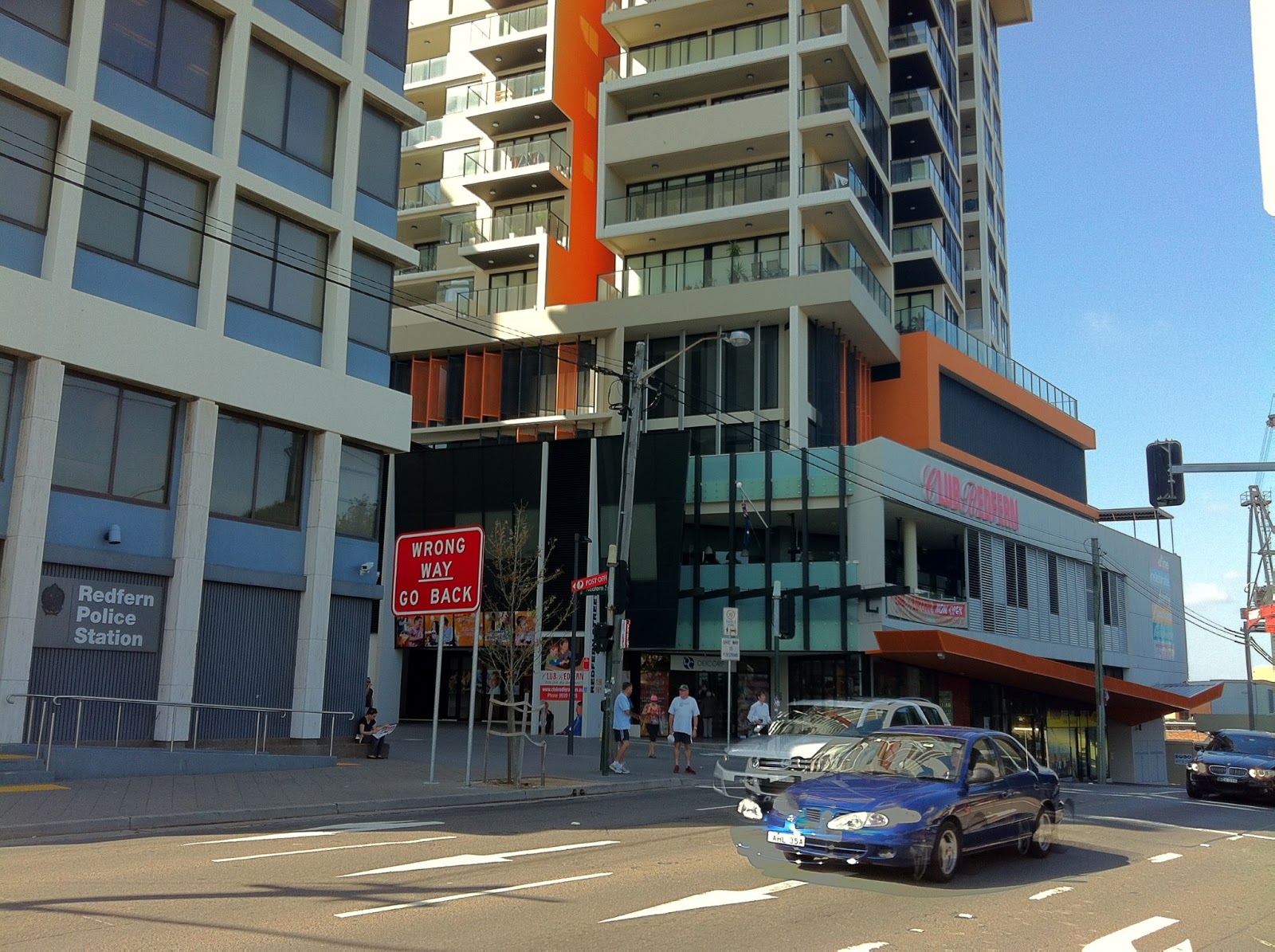
This reminded me of my observation of Redfern, where the juxtaposition of two scales creates a sense of identity, but not necessarily a positive one. This takes the form of the RSL residential tower, the police tower (12 and 13 storeys respectively) and the social housing towers which stand out among the low rise residential buildings around them. Each building is visible from multiple angles around the suburb, and the relationship of the buildings to the observer is while they may provide a landmark to orientate oneself and contribute to the sense of identity within Redfern, it may not be a positive one.
Thursday, April 18, 2013
BBC Articles
I was reading the BBC news website recently and there were several articles regarding cities that related to several comments made in class on Monday to the guest lecturer. This one regarding slums, and this one regarding sustainability, as well as this one.
Monday, April 1, 2013
Jan Gehl and every building on Anzac Parade
I was reading Life Between Buildings by Jan Gehl today in preparation for the City Observation assignment and came across these two paragraphs:


I have been complaining recently to other architecture friends of my opinion that the new colourful painted concrete/random facade treatments of basically every recent building on Anzac Parade is an eyesore, or will at least be an eyesore in 10 years when the paint is peeling and every sill has water stains. Its my opinion that the random facade treatments where an orange panel might be juxstaposed to a brick wall to a navy painted wall to a white extrusion are extremely unappealing and a cheap way of trying to inject life and energy into a main transport artery.
This feeling also applies to the ugly monolithic RSL building next to the Redfern trainstation, which gives almost no concession to the public at ground level. Composed of intruding/extruding panels, some of which are grey, orange and white, the building takes up a massive chunk of sky and is completely out of scale with the surrounding suburb, with the exception of the Police building next to it. It is as though the architect completely ignored what it means for a pedestrian to have real and actual experiential stimulation (cafes, open shopfronts, plantings etc) and simply stuck on a few coloured panels. I feel that the line "coloured concrete and staggered building forms" can be applied specifically to this RSL building. Coloured panels used in an unmeaning way does not create character.
Wednesday, March 20, 2013
Redfern Thoughts
Been spending some time walking around Redfern.
In an effort to try to comprehend the suburb, where people congregated, main infrustructure nodes etc I compared it to Surry Hills or even Paddington; areas of gentrification.
If we look at Redfern I couldn't really see any main streets or areas where significant amounts of people congregated, e.g. that were "Crown St"-esque. Instead, little pockets of cafes, restaurants and bars, as well as some parks seemed to be where small amounts of people congregated, and that these areas were spread out throughout the suburb. Paddington has its Oxford St, Surry Hills its Crown St, which are both fairly major thoroughfares when moving through the suburb. However Redferns main thoroughfares would probably be Gibbons St next to the train station, which provides access towards the city, and Redfern Street, which is smaller scale. Gibbons Street is noisy and loud, and it is no surprise that it is not pleasant to be around. Redfern Street I feel has potential, with the newly developed BVN park adjacent and lots of retail shops, but a significant minority of shops were empty storefronts waiting to be leased.
If we look at the transport in the area, the busiest area (disregarding the roads) would be Redfern Station. Watching the station in the morning saw it extremely busy as people went to work. Despite this, the public areas around the station were not particularly pleasant, and access points were awkward and congested. It struck me that the Station really just acted as a transit point, there was nowhere to meet people or spend time. Should this be improved?
Furthermore I realised that Redfern was potentially a suburb of dispersal, as opposed to congregation. Surry Hills and Crown St I would suggest are areas where people congregate, and yet in Redfern there are no real areas to congregate. You get off your train from work, and walk home via networks of laneways. Different precincts such as the station, the Australian Tech Park, the BVN park, the social housing towers, are not linked by any large roads but medium to small streets and laneways. It made me wonder what the qualities f the public areas are like (mostly not great), do people actually use them (sometimes), do they have multiple uses (no, excepting the BVN park), are laneways considered public spaces (yes), how do they affect people moving around the area, what infrastructure is linked to the public areas, and if we use Redfern Station as a generator for people, what are the public areas and thoroughfares surrounding it like?
Saturday, March 16, 2013
Assignment 1
I've been considering what area to do for the City Observation Exercise and came up with three potential sites.
1. Surry Hills - Crown Street
I have recently been spending a lot of time on Crown Street in Surry Hills, as I have just begun working in a restaurant there. I usually get to the area a little earlier than my starting time so to kill time I will go sit in Shannon Reserve next to the Clock Hotel. What struck me about the area is that it seemed to embody so much of the diversity that Jane Jacobs mentions in her book, as well as what WH Whyte mentions in his analysis of small city spaces. Any time of the day, you will get people going to the park (which in a way reminds me of a living room as all the seats are along the perimeter facing inwards) and people will be there playing with children, enjoying the sunshine, chatting to friends in little circles on the grass, or reading/listening to music.
The little square of grass next to Surry Hills Library is also one of my favourite places places in the whole of Sydney. Sitting there you can people watch as people enter the space off Crown St, watch the cars and pedestrians in front of you, get glimpses into the park, and watch the people on the balcony of the Clock Hotel as they watch the street below. Just that little area has so many layers of physical, aural and visual interaction. I recall one time not long ago I was sitting on the balcony of the Clock Hotel, and we saw as an brass band decided to display an impromptu performance walking up and down Crown St, stopping in front of the grass next to the Library, while some (probably inebriated) onlookers started dancing.
However as much as I love Surry Hills I feel like it is almost too perfect. It's a suburb that embodies almost everything I find successful about inner city living - proximity to public transport and infrastructure, clean and interesting laneways (which seem safe even walking at night), interesting cafes, bars and shops. I feel like the other sites I was looking at are so much more complex and need to be 'fixed', such as Redfern or Maroubra Junction.
2. Maroubra Junction
I very briefly considered doing Maroubra Junction for my project. I live close by to it and my bus often passes through the area. What both attracted me to consider the Junction for the project is the diversity of the population demographically, diversity of building types, as well as the odd, awkward public spaces. The diversity of building types includes high rise residential, semi detached and detached family homes, small shops, restaurants (including a McDonalds and a Yum Cha), retirement homes, and social housing close by. I think this reflects itself in the population as the population mix includes students living in the high rise residential, the elderly, the disadvantaged, families, and young professionals.
At the night, the area is one that I avoid, not because it is unsafe, but it feels unsafe. The street lighting is poor in areas, the place is deserted (especially the carpark that separates both sides of Anzac Pde), and waiting at the bus stop is such that they now post security at bus stop near the corner of Maroubra Rd and Anzac Pde. It is strange as it seems to almost tick all Jacobs "diversity" boxes, and yet at night the place feels uncomfortable and in my opinion, a bit ominous.
3. Redfern - area around the station, Redfern Street
Redfern is such a complex, fragmented suburb I almost don't know how to describe it. The eastern part is almost like the Surry Hills laneways, a fine grain network of fairly clean and safe laneways and streets. As one moves west however and along the main Redfern distributor that is Redfern St, the social housing towers come into view. Walking around the area of the towers is almost pleasant as there is an extremely large setback to the towers, planted with trees and filled with birds, but the presence of the towers and some of the human population makes it slightly less idyllic. Then near to the towers next to Redfern St is the recently gentrified Redfern Park and Oval, with little cafes, bars and restaurants nearby. The large presence of students is also interesting due to the proximity to Sydney University, and price of the housing.
What I would love to study about the area is how the public areas - parks, squares, setbacks and streets- link or divide all these highly diverse areas. Do they add or take away from the social fabric? How do people use them? Are they successful?
Ashleigh
Tuesday, March 12, 2013
Fukushima
In design studio, myself and a partner are studying "Drosscape" and what a drosscape is in relation to Redfern and Redfern Station. We are doing this in reference to articles written bu Lars Lerup, Manuel De Sola-Morales, and Alan Berger.
Drosscape, as written by Berger whom based his writing on a manifesto by Lerup, essentially describes drosscape as wasteland left over from past politico-economic regimes. They formed from two main processes, rapid horizontal growth (i.e. urban sprawl) or left over fragments from industrial regimes within the city (i.e. the industrial core).
One of the waste landscape "types" is the "waste landscape of contamination", and in a presentation to my Studio class I included an aerial photo of Fukushima and the surrounding landscape. And then last night, my boyfriend sent me a link to something he had seen on the internet, where Google took a car to one of the deserted cities Namie.
Virtually driving through the streets is simultaneously both fascinating and highly emotive. What happens to a place like this in 10, 20, 50 years? Where are all the people? How will the government deal with the situation, will they eventually rebuild or leave the city to crumble? One of the main points Berger makes is that drosscapes are not always negative as they have the potential to be regenerated. It begs the question of what is the potential of Namie?
Also looking at drosscapes and urban sprawl took us to looking at photos of American suburbs and cities such as Los Angeles, where aerial photos in Bergers Drosscape book showed the grid with single detached homes stretching into the horizon. It makes me wonder what it is like to live in a city where a vast area of it is repetitive can only be traversed by car.
Ashleigh
Tuesday, March 5, 2013
Some interesting links
I have been reading a lot of articles on a website called The Atlantic Cities. Many of the articles deal with Architecture/Urban Design which are highly interesting. Several articles relevant to the course include:
The Power of the Moveable Chair by William H Whyte, of whom was mentioned in the first lecture.
Intro
Hi!
This is my UDE0004 blog where I will be recording my thoughts, interesting articles & links regarding the course.
Some background: I am a Masters of Architecture student. I recently took a year off between Undergrad and Masters, and spent this year living in Dublin, Ireland. Prior to Architecture I had aspirations to be a Veterinarian and spent a year and a half at Sydney University studying Animal and Veterinary Bioscience before deciding time spent in the company of sheep and cows was not for me. I am still highly interested in science, particularly biology.
Some background: I am a Masters of Architecture student. I recently took a year off between Undergrad and Masters, and spent this year living in Dublin, Ireland. Prior to Architecture I had aspirations to be a Veterinarian and spent a year and a half at Sydney University studying Animal and Veterinary Bioscience before deciding time spent in the company of sheep and cows was not for me. I am still highly interested in science, particularly biology.
Thanks for reading,
Ashleigh
Subscribe to:
Comments (Atom)